Spatial Analysis of Soil Lead Exposures from Lead Poisoning Tragedy in Nigerian Mining Villages
By: Madi Thurston Email: thur8631@vandals.uidaho.edu
Home Town: Kuna, ID High School: Kuna High School
Major: Env Sc-Physical Science Opt
Department: Environmental Science
College: College of Natural Resources

Abstract
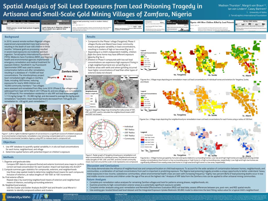
In 2010, an unprecedented lead poisoning in Zamfara State, Nigeria resulted in the death of more than 400 children. The outbreak was caused by artisanal processing of lead-rich gold ores inside rural village homes, where incidental ingestion of contaminated soils and dusts resulted in geomean blood lead levels (BLLs) of 149 µg/dL and maximum BLLs of 600 µg/dl. Soil lead concentrations in villages averaged 300-4,143 mg/kg with a maximum of 35,380 mg/kg, regularly exceeding the United States Environmental Protection Agency safe soil lead level of 400 mg/kg. To address the environmental health emergency, the Nigerian government partnered with international organizations, including TerraGraphics International Foundation (TIFO) and Doctors Without Borders (Médecins Sans Frontières, MSF) to remediate residential areas and deliver life-saving medical treatment for poisoned children. Archived in situ field-portable x-ray fluorescent spectrometer (FP-XRF) data from the environmental response provides a unique opportunity to develop a better understanding of heavy metal exposures that can be applied to other artisanal mining and indigenous communities.
To assess spatial variability in FP-XRF soil lead concentrations, an attribute database for residential compound soil lead levels was built in ArcGIS™ for three time periods: pre-remediation, post-remediation, and remediation follow-up assessments. Household, neighborhood, and community means were calculated for each compound. Neighborhood concentrations consist of a mean of all compound and public area locations within a radius of each home. The appropriate radius value (e.g., 200’, 300’, 400’) should reflect a child’s independent mobility and is likely influenced by several factors, including age and gender. This study demonstrates that neighborhood size, contamination variability, and compound location within the neighborhood have a significant impact on a child’s exposure to contaminated soil. Future work will investigate the relative contributions of home, neighborhood, and community exposures by comparing observed versus predicted BLLs using the Integrated Exposure Uptake Biokinetic (IEUBK) model.
Products Produced:
| Type: | Title: | Date Published/Presented: | DOI: |
|---|---|---|---|
| Poster | Spatial Analysis of Soil Lead Exposures from Lead Poisoning Tragedy in Artisanal and Small-Scale Gold Mining Villages of Zamfara, Nigeria | July 24, 2020 |
Additional Project Information:
Year in College Project Started: Senior
Faculty Advisor: Magrit von Braun
Faculty Advisor Email: vonbraun@uidaho.edu
Funding Source: Office of Undergraduate Research (SURF)
External Link to Project Information: https://www.terragraphicsinternational.org/nigeria
Project Location: Remote

